


Yes, the online service "Snow Load Zones, Wind Zones, and Seismic Zones" provides a background Web service for determining location-specific loads without opening the website.
The Web service can be used for all load maps from the visible online service and is controlled via a URL address. In this process, an external process (your application) sends a request URL address to our server (Dlubal) and receives the load information in CSV format as a result. For the process to work, the URL address must contain all the information needed to define the load type, standard, geoposition, output language, and user. The final URL is then composed of these components.
The load type and standard are defined using the "map" component. The 1st part describes the load type (e.g., snow, wind or earthquake) and the 2nd part the standard (e.g., din-en-1991-1-3).
→ map=snow-din-en-1991-1-3
The geoposition is defined using the "place" or "position" component. The "place" option works like the search option in the visible online service. Here, the geoposition is determined using search terms, address, etc. The "position" option defines the geoposition using geographic coordinates in the format [latitude in °, longitude in °].
→ place=messe, düsseldorf
→ position=51.2624991,6.735927199999992
The output language of the results is defined using the "language" component. The language is defined by an abbreviation (de - German, en - English, etc.)
→ language=de
The identity of the user is defined using the "login" and "hash" components. The "login" component describes the user's email address and the "hash" component a concealed password. For a working login, the email address must be stored in a valid Dlubal account. The associated "hash" component is provided in the Dlubal account under the section "My Data" - "Online Service Identity".
→ [email protected]
→ hash=xyz
From these components, a request URL can be finally generated and sent to our server.
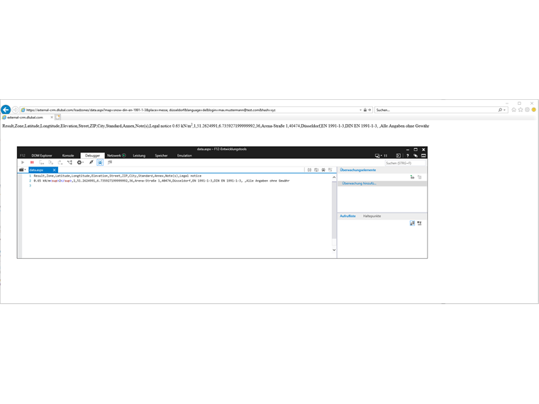
→ https://external-crm.dlubal.com/loadzones/data.aspx?map=snow-din-en-1991-1-3&place=messe, düsseldorf&language=de&[email protected]&hash=xyz
By sending the request, the requested load information is returned by our server in CSV format.
To send unlimited load queries to our server, a Geo-Zone Tool Package is necessary. Such a Geo-Zone Tool Package contains a specific quota of load queries. With each load query, the quota is reduced by one.
Since the Web service uses the purchased quota, careful handling of the identity components and the request URL is necessary with regard to data protection. For example, ensure that your program does not present the request URL with identity components to any unauthorized third party.
Further FAQs about the Geo-Zone Tool and the API: